Canadian River NFCA Profile
Conservation Profile
Ecoregion
Southern Plains
Biotic Province
Kansan
Stresses
Primary – include groundwater extraction, habitat fragmentation, dewatering, flow regime alteration, water pollution, and introduction of non-native species including invasive Saltcedar
Partners
Texas Tech University, NM Office of the State Enginner/Interstate Stream Commission, Canadian River Municipal Water Authority, United States Fish and Wildlife Service, Texas Parks and Wildlife, Oklahoma Department of Wildlife Conservation, Canadian River Landowner Conservation Cooperative, Texas Water Development Board, The Nature Conservancy
Fishes of concern
Peppered Chub (Macrhybopsis tetranema)
Arkansas River Shiner (Notropis girardi, federally threatened)
Suckermouth Minnow (Phenacobius mirabilis)
Flathead Chub (Platygobio gracilis)
Red River Pupfish (Cyprinodon rubrofluviatilis)
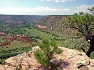
The Canadian River is the longest tributary to the Arkansas River and drains portions of Texas, New Mexico, and Oklahoma. Its headwaters are fed by snowmelt in the Sangre de Cristo Mountains of southern Colorado where they flow through pine forests and lush meadows. As the river travels southeastward across the short grasses of the arid Great Plains, it separates the Llano Estacado from the north High Plains, and carves steep bluffs, dune terraces, and rocky canyons (TSHA, TNC, NM Game & Fish). Through western and central Oklahoma, the Canadian becomes a “wide sandbed river”, traversing tall and mixed grass prairies and cross timbers regions (Matthews et al. 2005). In eastern Oklahoma, the river crosses more mesic lands (Matthews et al. 2005). Its large amounts of quicksand and deep gorge make it difficult to bridge (TSHA).

The Canadian River flows through only one freshwater ecoregion and has less biodiversity than the more expansive Arkansas that it contributes to. Further, this river lacks the salt gradients that structure diversity in the Red. It has been described as one of the harshest environments on Earth for aquatic life due to the climate extremes that limit its habitats. The upper river flows through an arid region of hot, dry summers and cold, blizzardy winters. The shallow, sandbed of the main channel is exposed to extreme solar heating in the summer, where temperatures become lethal. This is punctuated by strong flooding. Important fish habitat is relegated from the main channel to the deeper, more stable pools near creek inflows (Matthews et al. 2005).

The Canadian River traverses mostly rural country. In New Mexico and Texas, the only major city near the river is Amarillo and grazing is the dominant land use. In Oklahoma, the river is strongly influenced by agriculture, ranching, and oil production. There is “extensive” disturbance to the riverbed near Norman due to commercial sand mining (Matthews et al. 2005). In Oklahoma City, there are three dams that provide water for a system of canals that is a recreational tourist attraction (news article, Matthews et al.). The Nature Conservancy describes the condition of the Canadian River and its floodplain as fair (TNC). The grasses and wildflowers of the uplands were historically maintained by grazing bison, elk, and pronghorn, fires, and large numbers of black-tailed prairie dogs. These fire and grazing patterns have been disrupted, changing habitats and threatening species and communities. Invasive plants, conversion to agriculture, and flow regime modification have altered the structure of riparian forests (TNC).
The waters of the Canadian River basin have historically generated controversy between states. The Canadian River Compact between New Mexico, Oklahoma, and Texas ensures that each state receives equitable shares of quality water as apportioned by the compact limits on conservation pool storage in reservoirs (TCEQ, TSHA). There are two major reservoirs: the Conchas Reservoir (1939) and the Ute Reservoir (1963) (NM Wildlife). Damming combined with groundwater withdrawal have decreased river width by 90% since the 1930s. Historically, the Canadian occupied its entire valley; whereas, now it occupies a narrow channel (TNC). Dams have disrupted the natural flow cycle, altered habitat distribution, and fragmented river habitat, disrupting fish migration and isolating populations (NM Fish & Game). Once common fishes, whose reproductive cycles were adapted to the harsh flow regimes, now occur in substantially lower numbers (Matthews et al. 2005).
The Canadian River still provides habitat for migrating and nesting birds, including the least tern, as well as the Arkansas River Shiner. Several places along the river are protected and managed by the Nature Conservancy and private landowners (Matthews et al. 2005). Riverine habitat management may mitigate habitat loss and improve habitat quality for aquatic wildlife of the prairie (TNC).
Existing Conservation/Research Efforts:
- Packsaddle Conservation Area in OK (Nature Conservancy): crucial habitat for lesser prairie chicken, interior least turn, and Arkansas River Shiner
- Four Canyon Preserve (Nature Conservancy): “3,410 acres of mixedgrass prairie, rugged canyons and stream frontage along the Canadian River in southern Ellis County…. provide habitat for a number of rare grassland birds including Cassin’s sparrow, Swainson’s hawk and additional species of concern including reptiles, and plants… provides habitat the endangered least tern, the threatened Arkansas River shiner as well as stopover habitat for migratory shorebirds including the sandhill crane”
- Goals and Strategies for Packsaddle/Four Canyon:
- Restore a fire return interval of 3-7 years to 50,000 acres within the Packsaddle Conservation Area.
- Protect and enhance 15,000 acres of mixedgrass prairie.
- Protect 25 miles of riparian forests
- Protect and enhance nesting habitat for the least tern along 10 miles of the Canadian River.
- Maintain stream flow in the Canadian River
- Protect and enhance 25,000 acres of sand sage-brush and shinnery oak shrubland
- Establish baseline data and long-term monitoring sites for plants, animals, and natural communities
- Control infestations of salt cedar and eastern red cedar to restore and maintain habitat quality
- The Canadian River Municipal Water Authority, in cooperation with the Service, is working to control invasive salt cedar (Tamarix ramosissima) throughout the South Canadian River and its tributaries. Since 2004, over 26,000 acres of invasive salt cedar have been removed: https://www.fws.gov/endangered/map/ESA_success_stories/OK/OK_story2/index.html
Sources:
TSHA (Texas State Historical Commission): https://tshaonline.org/handbook/online/articles/rnc02
TNC (The Nature Conservancy): http://www.nature.org/ourinitiatives/regions/northamerica/unitedstates/oklahoma/explore/packsaddle-1.pdf
New Mexico Game & Fish: http://www.wildlife.state.nm.us/download/fishing/maps/Canadian-River-Native-New-Mexico-Fish-Poster.pdf
Matthews et al. 2005: http://www.biosurvey.ou.edu/download/publications/South_Plains_River_Complete.pdf
News article: http://newsok.com/article/3857471
TCEQ: https://www.tceq.texas.gov/permitting/compacts/canadian.html
