The Arkansas River
Southern Plains, Central Prairie
Conservation Profile
Freshwater Ecoregions
Southern Plains, Central Prairie (the river also includes the Ozark Highlands and Mississippi Embayment, but these are beyond the GPLCC Boundary)
Stresses
Channel modification, impoundments, overappropriation of surface waters, groundwater withdrawal, pollution/water quality (industrial, agricultural, livestock, wastewater), invasive species, reservoir sedimentation, algal blooms
Partners
Kansas Alliance for Wetlands and Streams
Arkansas River Coalition
Oklahoma Water Resources Board
America’s Watershed Initiative
Arkansas-Kansas River Compact
Kansas-Oklahoma Arkansas River Compact
Kansas Department of Agriculture
USGS
Kansas Water Science Center
Kansas Department of Wildlife, Parks and Tourism
Oklahoma Water Resources Board. Beneficial Use Monitoring Program
River Projects Tulsa
U.S. Army Corps of Engineers
USFWS
Kansas Wildscape Foundation
Fishes of Concern
Paddlefish (Polyodon spatula)
Shortnose Gar (Lepisosteus platostomus)
Southern Redbelly Dace (Chrosomus erythrogaster)
Brassy Minnow (Hybognathus hankinsoni)
Plains Minnow (Hybognathus placitus)
Cardinal Shiner (Luxilus cardinalis)
Common Shiner (Luxilus cornutus)
Sturgeon Chub (Macrhybopsis gelida)
Shoal Chub (Macrhybopsis hyostoma)
Peppered Chub (Macrhybopsis tetranema)
Hornyhead Chub (Nocomis biguttatus)
Emerald Shiner (Notropis atherinoides)
River Shiner (Notropis blennius)
Arkansas River Shiner (Notropis girardi)
Topeka Shiner (Notropis topeka)
Suckermouth Minnow (Phenacobius mirabilis)
Slim Minnow (Pimephales tenellus)
Blue Sucker (Cycleptus elongatus)
Neosho Madtom (Noturus placidus)
Northern Plains Killifish (Fundulus kansae)
Plains Topminnow (Fundulus sciadicus)
Arkansas Darter (Etheostoma cragini)
Sauger (Sander canadensis)
General Description
 Born from creeks at nearly 10,000 feet in the Rockies of Colorado, the Arkansas River descends 2 miles in elevation as it travels through Kansas, Oklahoma, and Arkansas to its confluence with the Mississippi River. The French named the river the Arkansas in reference to a local American Indian Tribe. Its basin is the largest in the southern Great Plains. At 1,469 miles, the second longest tributary in the Mississippi watershed passes through a greater diversity of climate, terrain, and land use than any other Great Plains river.
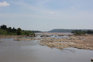
The Arkansas is the most likely influenced by Rocky Mountain snowmelt among southern Great Plains rivers. The upper section in Colorado is cold. Swift flows through steep, rugged terrain support world-class white water sections, rendering the river the most commercially rafted in the U.S.. Leaving the coniferous uplands, the Arkansas enters the Great Plains near Pueblo, CO. The vigorous flows of the Rockies are lost to evaporation and withdrawal among the short, native grasses of Western Kansas. Here, the river is low-gradient and ephemeral. The Arkansas recharges and widens downstream from Great Bend, its swift currents traversing gravely riffles. At Wichita, it takes on the sandy, braided channels that characterize other Great Plains rivers. It continues to gain, becoming a major plains river, as it traverses mixed and tallgrass prairies. In Tulsa, the flows of the wide, braided channels are tightly regulated by reservoir releases, but human interference is even greater with the Arkansas’ juncture with the Verdigris River. From here, the Arkansas is the Kerr-McClellan Navigation System, a series of 18 locks and dams that provide commercial navigation, flood control, municipal and industrial water supplies, and hydroelectric power.
The Arkansas River Basin contains the Arkansas River Lowlands, flat alluvial plains that include salt marshes and sand prairies. These areas serve as prime staging grounds for North American shorebird migrations. Portions of the Arkansas’ main channel are critical habitat for the federally threatened Arkansas River shiner. Beaches and sandbars host breeding populations of the federally endangered interior least tern.

Identifying Stresses
The Arkansas River through Oklahoma and Arkansas has been severely affected by channel modification, impoundments, and other navigation-control structures. Dams and their resulting reservoirs deepen and widen the channel, affect flow and sedimentation regimes, and fragment and obstruct habitat. There has been an extreme loss of water from the main channel in western Kansas due to groundwater withdrawal for agricultural irrigation. A complete loss of surface flow has resulted in several places for as much as a year. Overallocation is an ongoing problem and there are two interstate compacts. Recreation has been discouraged near Tulsa due to water pollution from wastewater, storm water, and abandoned oil and gas wells.
Existing Conservation and Research Elements
 The Oklahoma Water Resources Board oversees a Beneficial Use Monitoring Program. These studies provide data for water quality management and protection from an economic and recreational standpoint. Recreation is being encouraged again in Tulsa with improvements in wastewater treatment and cleanup of well sites; although, the EPA still designates waters through Tulsa unsafe for ingestion. The Arkansas River Compact between Kansas and Oklahoma encourages an active pollution abatement program in addition to divvying up waters. The Arkansas River Corridor Master Plan was developed with the help of the U.S. Army Corps of Engineers and includes developments for conservation and improvements to native riverine habitat as well new gates to existing dams for fish passage and sediment management in addition to recreational features. Other recreational improvements including the National River Trail designation from Great Bend to the Oklahoma Border. This 192 mile scenic riparian corridor through prairie, pasture, and farmland includes 22 public access areas. The Arkansas River Coalition hosts dozens of guided river floats along the trail. Getting more people on the river will serve to generate interest in its conservation.
Sources
- http://www.biosurvey.ou.edu/download/publications/South_Plains_River_Complete.pdf
- http://wichita.kumc.edu/Documents/wichita/wire/Arkansas-River.pdf
- http://www.okhistory.org/publications/enc/entry.php?entry=AR010
- http://agriculture.ks.gov/divisions-programs/dwr/interstate-rivers-and-compacts/kansas-oklahoma-arkansas-river-compact
- https://stateimpact.npr.org/oklahoma/2015/10/08/tulsa-area-leaders-push-to-change-the-arkansas-rivers-tainted-image/
- http://ian.umces.edu/pdfs/ian_newsletter_450.pdf
- http://riverprojectstulsa.info/index.php/the-arkansas-river-corridor-master-plan
- https://ecos.fws.gov/docs/federal_register/fr5149.pdf
- http://www.legendsofkansas.com/arkansasriver.html
- http://www.kansas.com/sports/outdoors/article87381132.html
- http://www.kgs.ku.edu/Extension/lowlands/places.html