In 2015, the Little Tennessee River watershed became the nation’s first Native Fish Conservation Area (NFCA). NFCAs are watersheds that are managed for the conservation and restoration of native fish and other aquatic species, allowing compatible uses.
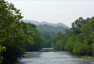
The Little Tennessee River watershed spans three states (Georgia, North Carolina, and Tennessee) and features a diverse set of aquatic habitats, from high elevation coldwater trout streams to warmwater rivers to large reservoirs. Historically, it was one of the more biologically rich watersheds in the nation, but aquatic communities have been impacted by a host of stressors, including dams, agriculture, industrial pollutants, piscicides and development. Some streams impacted in the past now offer restoration opportunity, and numerous efforts are underway to restore native fish to streams on the Great Smoky Mountains National Park, on US Forest Service land, on the Eastern Band of Cherokee Indians reservation and on private lands.
More than twenty-five organizations, including federal and state agencies, industry, and non-government entities, form the Native Fish Conservation Partnership (NFCP). The NFCP supports work already underway by partners by providing additional funding, public exposure, and a mechanism for collaboration. It implements educational initiatives, including a snorkeling education program, a riparian education and restoration initiative, and a video project, which will result in a series of Freshwaters Illustrated videos on the biodiversity of the Little Tennessee River basin, the importance of clean water to industry, agriculture, and recreation, restoration efforts and the importance of river stewardship.
Perhaps most importantly, the NFCP provides a forum to plan and implement watershed conservation on a landscape scale. Partners are developing an on-line mapping platform, which will be used to house data, map threats, identify focal areas for restoration and protection and ultimately serve as a conservation plan for the watershed.